Evaluation of RADARSAT Standard Beam data for identification of potato and rice crops in India
S. Panigrahy, K.R. Manjunath, M. Chakraborty, N. Kundu, J.S. Parihar
ดาวเทียม RADARSAT ของแคนนาดา ถูกปล่อยขึ้นสู่วงโคจรในเดือน พฤศจิกายน 1995 ประกอบด้วย ช่วยคลื่น C-Band HH polarisation Synthetic Aperture Radar (SAR) มีความหลากหลายทางด้านแง่มุมและความละเอียดเชิงพื้นที่ ในการศึกษานี้ ข้อมูล the Standard Beam S7 SAR ที่มุม 45-49 องศา นั้นได้ถูกใช้ในการแยกแยะให้เห็นความแตกต่างระหว่างพื้นที่ปลูกข้าวกับมันฝรั่ง ในการเจริญเติบโตในพื้นที่ west ฺBengal โดยได้ข้อมูลมาทั้งหมด 4่ ช่วงเวลา ในทุกๆ 24 วันของรอบการบันทึก ระหว่างวันที่ 2 มกราคม ถึง 15 มีนาคม 1997 ถูกใช้ในการศึกษาเกี่ยวกับลักษณะการสะท้อนในแต่ละช่วงเวลาของพืชเหล่านี้ ที่มีความสัมพันธ์กับการเจริญเติบโต ในช่วงที่ 2, 3 และ 4 นั้นถูกใช้ในการจำแนกพืช ในผลการศึกษาพบว่าการสะท้อนกลับที่มีค่าต่ำที่สุดอยู่ในพื้นที่นาข้าวในระยะเริ่มเพาะปลูกที่มีน้ำขังอยู่ในแปลงพื้นที่ และการมีการเพิ่มขึ้นตามกระบวนการเจริญเติบโต ในการสะท้อนกลับนั้นพบว่า มีช่วงการเปลี่ยนแปลง จาก -18 dB ถึง -8 dB จากพฤติกรรมที่มีการเปลี่ยนแปลงในแต่ละช่วงเวลานั้นมีความเหมือนกับข้อมูล ERS-SAR ความถูกต้องจากการจำแนกประเภทข้อมูลในพื้นที่เพาะปลูกข้าว พบว่า 94% โดยการใช้ข้อมูลทั้ง 4 ช่วงเวลา ในการใช้ข้อมูล 2 ช่วงเวลามีความสอดคล้องกัลในช่วงที่มีการเตรียมการเพาะปลูกของพืชและสอดคล้องกับการเจริญเติบโตในระยะอื่นๆ ผลการศึกษาทีความถูกต้อง 92 % การสำรวจสุดท้ายเป็นความสนใจโดยเฉพาะคือการประมาณพื้นที่เพาะปลูกในช่วง 20-30 วันของการเจริญเติบโต เช่นการประเมินการเจริญเติบโตในระยะแรกนั้นไม่เป็นไปได้ โดยการใช้ข้อมูล optical remote sensing การสะท้อนกลับของมันฝรั่งมีความแตกต่างในช่วง -9 dB ถึง -6 dB ระหว่างการเจริญเติบโตและแสดงความแตกต่างอย่างมากในช่วงการเติบโตของพืชในระยะแรก ข้อมูลสองช่วงเวลาอยู่ในช่วงระหว่าง 40-45 วัน ของการเจริญเติบโตจากการวัดค่า โดยผลลัพท์คือ 93 % จากการจำแนกความถูกต้องของมันฝรั่ง ในการรวบรวมด้านอื่นของ ข้อมูลสองช่วงเวลานั้นมีค่าความถูกต้องน้อยกว่า 90 % ของมันฝรั่ง
วันพฤหัสบดีที่ 16 เมษายน พ.ศ. 2558
Land use and land cover change affecting habitat distribution in the Segara Anakan lagoon, Java, Indonesia
Erwin Riyanto Ardil - Matthias Wolff
งานวิจัยนี้ทำการศึกษาเกี่ยวกับการใช้ที่ดินและสิ่งปกคลุมดินในเขตพื้นที่ Segara Anakan lagoon, Java, Indonesia ในช่วงปี 1987-2006 โดยใช้ภาพถ่ายดาวเทียม 4 ช่วงเวลา ได้แก่ 1987, 1995, 2004 และ 2006 โดยใช้ข้อมูล Ground control point ในปี 2004 และ 2005 และข้อมูลการตรวจสอบความถูกต้องในปี 2004 จากการวิจัยพบว่า ในช่วงตะวันตกของพื้นที่ศึกษา มีการเพิ่มขึ้นของพื้นที่การปลูกข้าวโพด และการการทำการเกษตรแบบแห้งแล้ง การเพาะเลี้ยวสัตว์น้ำและพื้นที่ชนบท โดยมีการลดลงของพื้นที่ป่าชายเลน พื้นที่โคลนและทะเลสาป ในส่วนของทางตะวันออก มีการลดลงของป่าชายเลนและมีการเพิ่มขึ้นของการเพาะเลี้ยงสัตว์น้ำ ที่อยู่อาศัยและแหล่งอุตสาหกรรมที่ได้จาการสำรวจ การเปลี่ยนแปลงนั้นเกิดการการเติมเต็มของตะกอนในทะเลสาป ที่มีการไหลจากพื้นที่ด้านในลงมาในทะเลสาป ผลจากการศึกษานี้เป็นข้อมูลเบื้องต้นในการต้องการพัฒนาพื้นที่ไปข้างหน้าเพื่อให้เกิดความยั่งยืนในการใช้ทรัพยากรต่อไป
วันอังคารที่ 6 มีนาคม พ.ศ. 2555
QGIS Version 1.7.4 'Wroclaw'
QGIS เวอร์ชั่น 1.7.4 ได้ถูกพัฒนาเพื่อกำจัด bugfix ทั้งหลาย โดยมี
การใส่ชื่อรุ่นเวอร์ชั่นไว้ตั้งแต่รุ่นที่ 1.7.x ที่ีมีชื่อว่า 'Wroclaw' โดยชื่อดังกล่าว
ได้ถูกตั้งมาจากเมื่องที่กลุ่มผู้พัฒนาได้ไปพบปะกันที่เมืองดังกล่าว ในเืดือนพฤศจิกายน 2010
จึงได้ทำการตั้งชือเวอร์ชั่นตามเมือง ซึ่งภาษาไทยอ่านว่า " วรอตซวาฟ " ซึ่งเป็นชื่อเมือง
ในประเทศโปแลนด์ โดยมีการพบกันที่ The Department of Climatology and Atmosphere Protection, University of Wroclaw
โดยเวอร์ชั่นนี้ได้กำจัด bugfix ที่ปรากฎในเวอร์ชั่น 1.7.3 โดยมีรายละเอียดดังนี้
- Fix #5010 Line intersection non fatal error
- Fix #2992 Use native Separators in Filename-edit-widget
- Fix #4633 'Save as...DXF' does not add file extension
- Fix #4412 Ftools: Input layers are not presented in alphabetical order
- Fix #4326 Use project title as default filename in Save and Save as dialogs
- Fix #4623 GPS plugin: 'Save as...' does not add file extension
- Fix #4652 Remove "unsynced" EPSG CRS that are not listed in GDAL
- Fix #4625 Enable wait cursor when WMS search is ongoing
- Fix #3845 Add support for modulo operator (%) in rule based rendering
- Fix #4193 GRASS Rasters are not drawn with user-defined style
- Fix #4557 Fix crash when project is not yet saved
- Fix #4315 'Stretch Histogram to full dataset' toolbar button does not work with GRASS rasters
- Fix #4632 More precise composer map rotation
- Fix #4664 Fix label orientation with line dependent position
- Fix #2435 Fix Query builder from layer properties when layer name in cyrrilic
- Fix #4684 Skip attribute values with invalid variant type
- Fix #4549 Update QgsGenericProjectionSelector bindings
- Fix #4129 GDAL provider: add statusChanged signal and fix debugging output
- Fix #4379 If set 'prompt for CRS', CRS is asked when creating new shapefile layer
- Fix #4694 Hourglass not shown when classifying
- Fix #4478 Actions using %% do not work from identify results
- Fix #4646 Editing of table of attributes goes Wild
- Fix #3963 Crash when applying a graduated vector style
- Fix #3185,#4689 Gps Tools: Allow user to add new ports
- Fix #4402 QGIS crashes displaying overview if diagrams are used
- Fix #4371 Identify tool does not work with reprojected WMS layers
- Fix #4305 Query builder: added ' ' around numeric fields (wrong)
- Fix #4217 Allow up to 5 decimal places for width/size Scale Field
- Fix #4452 Support for cyrillic symbols in raster metadata
- Fix #4558 Enhancements in OGR Provider
- Fix #3201 Show warning when user tried to create field 'shape' in shapefile
- Fix #4736 Do not create the .gislock file under Windows (as native GRASS now does)
- Fix #4523,#4737,#4738 Several Nodetool fixes
- Fix #4690 Crash when adding field to a shape file's attribute table
- Fix #2709 There is no default value of Categorized symbol in new symbology
- Fix #4693 Always save last used directory in Raster terrain analysis plugin
- Fix #4567 Fix Union tool to produce correct attribute table
- Fix #1209 Save last used directory and last used filter in GPSTools plugin
- Fix #206 (partial) Remember dialog size and position and restore them
- Fix #4138 Display real band number for multiband rasters when single band gray drawing style used
- Fix #4178 Display plugins from additional paths in Plugin Manager
- Fix #3763 Use native file dialogs wherever possible
- Fix #3189 Increase scale range
- Fix #4843 Fix highlighting for identify tool when OTF enabled
- Fix #4635 Attribute table edit button: only changes to columns are refreshed when Discarding changes
- Fix #4109 Save-as to 'original CRS' incorrectly reprojects if OTF reprojection is disabled
- Fix #5010 Fix Intersect lines tool
- Fix #4465 Make the GRASS plugin working with GRASS 6.4.2RC2
- Fix #4668 Make r.sunmask.position and r.sunmask.datetime work
- Fix #4965 Enable toggle editing button depending on layer type
- minor UI fix in New SpatiaLite Layer dialog
- Merge shapefile to one crash when used layers mode
- Reload default color table
- Fix for attribute shift in form when invoked from table
- Postgres provider: remove ctid limitation to 32bit
- Add extension to new SpatiaLite database if user ommits it
- Disable rendering while legend group is removed
- Query builder: support null values in values lists
- Avoid useless canvas redraw when user interacts with scale selector
- Clear collected plugins path before collecting svg path
- Case insensitive search for CRS in WMS provider
- New icons for RGB to PCT and PCT to RGB tools
- New gis theme icon for Merge shapefiles tool
- Several other small fixes
- Improved and updated Translation
ซึ่งผมคิดว่ารุ่นต่อไปน่าจะตั้งชื่อว่า Lisbon เป็นเมืองในประเทศโปรตุเกส ครับ
วันจันทร์ที่ 3 ตุลาคม พ.ศ. 2554
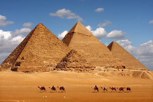
10 ตำนานลึกลับของอารยธรรมอียิปต์โบราณ
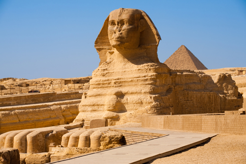

1. พระนางคลีโอพัตรา กับรูปโฉมที่แท้จริง
พระนางคลีโอพัตรา (Cleopatra VII) นับได้ว่าเป็นผู้ปกครองอียิปต์โบราณที่มีชื่อเสียงมากที่สุด ซึ่งในความรู้สึกนึกคิดของคนทั่วไป เธอคือพระราชินีผู้ทรงเสน่ห์ที่สุด มีรูปโฉมที่งดงาม เพียบพร้อมไปด้วยกลเม็ดเด็ดพรายในเชิงพิศวาส สามารถมัดใจชายได้อย่างอยู่หมัด แต่แท้ที่จริงแล้ว เสน่ห์ของพระนางคลีโอพัตราไม่ได้อยู่ที่เนื้อหนังมังสาหรือความงดงามแห่งใบหน้าและเรือนกายเลย แต่อยู่ที่สติปัญญาและความเฉลียวฉลาดรู้เท่าทันคนต่างหาก โดยมีหลักฐานชิ้นหนึ่งที่บ่งบอกถึงความจริงเรื่องนี้ ก็คือการค้นพบรูปปั้นส่วนพระเศียรขององค์ราชินีและเหรียญที่มีภาพพระพักตร์ของพระนาง ซึ่งเป็นการค้นพบของนักโบราณคดีรายหนึ่ง
พระนางคลีโอพัตรา (Cleopatra VII) นับได้ว่าเป็นผู้ปกครองอียิปต์โบราณที่มีชื่อเสียงมากที่สุด ซึ่งในความรู้สึกนึกคิดของคนทั่วไป เธอคือพระราชินีผู้ทรงเสน่ห์ที่สุด มีรูปโฉมที่งดงาม เพียบพร้อมไปด้วยกลเม็ดเด็ดพรายในเชิงพิศวาส สามารถมัดใจชายได้อย่างอยู่หมัด แต่แท้ที่จริงแล้ว เสน่ห์ของพระนางคลีโอพัตราไม่ได้อยู่ที่เนื้อหนังมังสาหรือความงดงามแห่งใบหน้าและเรือนกายเลย แต่อยู่ที่สติปัญญาและความเฉลียวฉลาดรู้เท่าทันคนต่างหาก โดยมีหลักฐานชิ้นหนึ่งที่บ่งบอกถึงความจริงเรื่องนี้ ก็คือการค้นพบรูปปั้นส่วนพระเศียรขององค์ราชินีและเหรียญที่มีภาพพระพักตร์ของพระนาง ซึ่งเป็นการค้นพบของนักโบราณคดีรายหนึ่ง
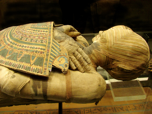
2. ความเชื่อเกี่ยวกับความตาย
ชาวอียิปต์โบราณมีความเชื่อที่ว่า เมื่อคนตาย ดวงวิญญาณจากร่างไปเพียงชั่วคราว เพื่อเดินทางไปพบกับพระเจ้าในโลกหน้า แล้วจะกลับมาในวันหนึ่งข้างหน้า ทั้งนี้ เมื่อวิญญาณกลับมาแล้วก็ต้องมีร่างกายอยู่ และร่างที่จะอาศัยอยู่ได้ต้องเป็นร่างกายของตนเองเท่านั้น และด้วยความเชื่อนี้เองจึงทำให้เกิดวิธีการดูแลศพ หรือที่เรารู้จักกันอย่างดีกับการทำ "มัมมี่" (Mummy) เพื่อให้สภาพศพยังอยู่ในสภาพที่ดี ไม่เน่าเปื่อยนั่นเอง
ชาวอียิปต์โบราณมีความเชื่อที่ว่า เมื่อคนตาย ดวงวิญญาณจากร่างไปเพียงชั่วคราว เพื่อเดินทางไปพบกับพระเจ้าในโลกหน้า แล้วจะกลับมาในวันหนึ่งข้างหน้า ทั้งนี้ เมื่อวิญญาณกลับมาแล้วก็ต้องมีร่างกายอยู่ และร่างที่จะอาศัยอยู่ได้ต้องเป็นร่างกายของตนเองเท่านั้น และด้วยความเชื่อนี้เองจึงทำให้เกิดวิธีการดูแลศพ หรือที่เรารู้จักกันอย่างดีกับการทำ "มัมมี่" (Mummy) เพื่อให้สภาพศพยังอยู่ในสภาพที่ดี ไม่เน่าเปื่อยนั่นเอง

3. การปรากฎตัวของเอเลี่ยน
ในทุกวันนี้กระแส "เอเลี่ยน" หรือมนุษย์ต่างดาว ก็ยังคงมีให้เห็นอยู่อย่างต่อเนื่อง แต่คุณรู้หรือไม่ว่า การปรากฎตัวของเอเลี่ยนมีให้เห็นมาแล้วตั้งแต่สมัยอียิปต์โบราณเลยทีเดียว สิ่งหนึ่งที่ยืนยันในเรื่องนี้ ก็มาจากภาพบนฝาผนังภายในสุสานในเมืองกิซ่า โดยหนึ่งในภาพบนฝาผนังนั้นมีการวาดภาพของเอเลี่ยนปะปนอยู่ด้วย แต่ทั้งนี้ทั้งนั้น ก็ต้องใช้วิจารณญาณในการตัดสินใจด้วย เพราะบางทีภาพ ๆ นี้ อาจจะเป็นเพียงแค่รูปของสิ่งของอื่น ๆ ที่มีลักษณะคล้ายกับเอเลี่ยนเท่านั้นเอง
ในทุกวันนี้กระแส "เอเลี่ยน" หรือมนุษย์ต่างดาว ก็ยังคงมีให้เห็นอยู่อย่างต่อเนื่อง แต่คุณรู้หรือไม่ว่า การปรากฎตัวของเอเลี่ยนมีให้เห็นมาแล้วตั้งแต่สมัยอียิปต์โบราณเลยทีเดียว สิ่งหนึ่งที่ยืนยันในเรื่องนี้ ก็มาจากภาพบนฝาผนังภายในสุสานในเมืองกิซ่า โดยหนึ่งในภาพบนฝาผนังนั้นมีการวาดภาพของเอเลี่ยนปะปนอยู่ด้วย แต่ทั้งนี้ทั้งนั้น ก็ต้องใช้วิจารณญาณในการตัดสินใจด้วย เพราะบางทีภาพ ๆ นี้ อาจจะเป็นเพียงแค่รูปของสิ่งของอื่น ๆ ที่มีลักษณะคล้ายกับเอเลี่ยนเท่านั้นเอง
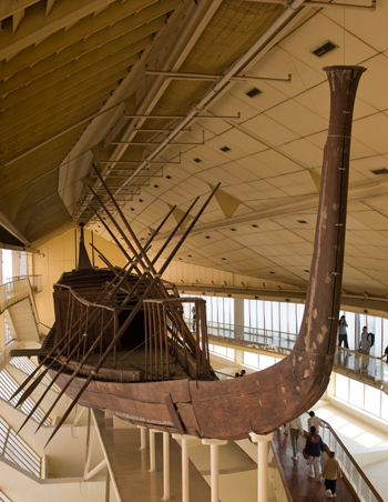
4. ที่สุดแห่งการค้นพบ
อีกสิ่งหนึ่งที่น้อยคนนักจะนึกถึงและรู้จักเกี่ยวกับประวัติของอิยิปต์โบราณก็คือในเรื่องของการค้นพบที่ยิ่งใหญ่ เพราะนอกจากมหาพีระมิดต่าง ๆ แล้ว ข้อมูลอันล้ำค่าทางประวัติศาสตร์ที่ค้นพบกันนั้นก็คือ "เรือโซล่าร์" (Solar Boat) หรือเรือแห่งแสงอาทิตย์ที่เชื่อกันว่า จะเป็นพาหนะที่นำพาวิญญาณขององค์กษัตริย์ไปหาเทพเจ้าแห่งแสงอาทิตย์บนสวรรค์ได้ เรือโซล่าร์นี้สร้างขึ้นจากไม้มากกว่า 1,200 ชิ้น สันนิษฐานว่าสร้างตั้งแต่ 2500 ปีก่อนคริสตกาล และอาจจะเป็นเพียงเครื่องบูชาพระศพในสุสาน ไม่ได้นำไปใช้ล่องในแม่น้ำจริง ๆ แต่อย่างใด
อีกสิ่งหนึ่งที่น้อยคนนักจะนึกถึงและรู้จักเกี่ยวกับประวัติของอิยิปต์โบราณก็คือในเรื่องของการค้นพบที่ยิ่งใหญ่ เพราะนอกจากมหาพีระมิดต่าง ๆ แล้ว ข้อมูลอันล้ำค่าทางประวัติศาสตร์ที่ค้นพบกันนั้นก็คือ "เรือโซล่าร์" (Solar Boat) หรือเรือแห่งแสงอาทิตย์ที่เชื่อกันว่า จะเป็นพาหนะที่นำพาวิญญาณขององค์กษัตริย์ไปหาเทพเจ้าแห่งแสงอาทิตย์บนสวรรค์ได้ เรือโซล่าร์นี้สร้างขึ้นจากไม้มากกว่า 1,200 ชิ้น สันนิษฐานว่าสร้างตั้งแต่ 2500 ปีก่อนคริสตกาล และอาจจะเป็นเพียงเครื่องบูชาพระศพในสุสาน ไม่ได้นำไปใช้ล่องในแม่น้ำจริง ๆ แต่อย่างใด
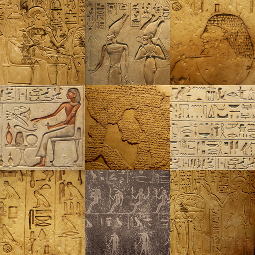
5. อักษรภาพอียิปต์โบราณ
อักษรภาพอียิปต์โบราณหรือที่เรียกกันว่า "ฮีโรกริฟฟิค" (Hieroglyphs) ถือเป็นอีกสิ่งหนึ่งในความอัศจรรย์ที่เกิดขึ้นบนโลกใบนี้ ความชำนาญทางศิลปหัตถกรรม งานช่าง และการทำหนังสือของชาวอียิปต์โบราณถือเป็นสิ่งที่น่าทึ่งมาก ๆ ซึ่งสะท้อนให้เห็นถึงความเชื่อของพวกเขาที่มีอำนาจและอิทธิพลต่อพิธีกรรมและการดำรงชีวิตอย่างสูง สำหรับอักษรภาพอียิปต์โบราณนี้ เป็นภาพอักษรที่มักจะสลักเรื่องราวเกี่ยวกับองค์ฟาโรห์ ราชวงศ์ การเมืองการปกครอง และเรื่องราวทางศาสนา ซึ่งจะมีปรากฎให้เห็นอยู่ตามวิหารและสิ่งก่อสร้างทั้งหลาย โดยแต่ละภาพก็จะมีการสื่อความหมายที่แตกต่างกันออกไป ซึ่งนี่เองจึงทำให้การค้นพบในครั้งแรก ๆ นั้น ก็สร้างความมึนงงให้เหล่านักสำรวจอยู่ไม่น้อยเลยทีเดียว

อักษรภาพอียิปต์โบราณหรือที่เรียกกันว่า "ฮีโรกริฟฟิค" (Hieroglyphs) ถือเป็นอีกสิ่งหนึ่งในความอัศจรรย์ที่เกิดขึ้นบนโลกใบนี้ ความชำนาญทางศิลปหัตถกรรม งานช่าง และการทำหนังสือของชาวอียิปต์โบราณถือเป็นสิ่งที่น่าทึ่งมาก ๆ ซึ่งสะท้อนให้เห็นถึงความเชื่อของพวกเขาที่มีอำนาจและอิทธิพลต่อพิธีกรรมและการดำรงชีวิตอย่างสูง สำหรับอักษรภาพอียิปต์โบราณนี้ เป็นภาพอักษรที่มักจะสลักเรื่องราวเกี่ยวกับองค์ฟาโรห์ ราชวงศ์ การเมืองการปกครอง และเรื่องราวทางศาสนา ซึ่งจะมีปรากฎให้เห็นอยู่ตามวิหารและสิ่งก่อสร้างทั้งหลาย โดยแต่ละภาพก็จะมีการสื่อความหมายที่แตกต่างกันออกไป ซึ่งนี่เองจึงทำให้การค้นพบในครั้งแรก ๆ นั้น ก็สร้างความมึนงงให้เหล่านักสำรวจอยู่ไม่น้อยเลยทีเดียว
6. การตกแต่งภายในพีระมิด
นอกจากโครงสร้าง วัสดุ และวิธีการสร้างพีระมิด จะมีความอลังการงานสร้างอย่างยิ่งใหญ่มาก ๆ แล้ว ภายในของปิระมิดเองยังมีการตกแต่งอยู่อย่างสวยงามตามสมัยอีกด้วย สิ่งหนึ่งที่พบได้ภายในพีระมิดนั้นก็คือ เหล่าบรรดาอักษรภาพฮีโรกริฟฟิค อายุอานามกว่า 4,000 ปี ซึ่งช่วยให้พีระมิดที่ค้นพบกันนั้น กลายเป็นสถาปัตยกรรมอันล้ำค่าและมีอายุเก่าแก่มากที่สุดแห่งหนึ่งของโลกใบนี้
7. องค์ฟาโรห์กับการฝังทาสรับใช้
หลังจากการสิ้นพระชนม์ขององค์ฟาโรห์แล้ว เหล่าบรรดาข้าทาสบริวารของพระองค์ไม่ได้ถูกฆ่าหรือโดนฝังทั้งเป็นในสุสานขององค์ฟาโรห์อย่างที่เคยทราบ ๆ กันแต่อย่างใด เพราะมีหลักฐานทางประวัติศาสตร์ชิ้นหนึ่ง ได้กล่าวไว้ว่า องค์กษัตริย์ฟาโรห์องค์สุดท้ายทรงเล็งเห็นว่า ข้าทาสของพระองค์ยังสามารถทำประโยชน์อื่น ๆ ได้มากกว่าการถูกฆ่าหรือฝังไปอย่างเปล่าประโยชน์ และเพื่อไม่ให้เป็นการขัดต่อประเพณีที่มีการสืบต่อกันมาช้านาน พระองค์จึงทรงรับสั่งให้นำ "ชับติ" (Shabti) หรือรูปแกะสลักที่ทำจากหลากหลายวัสดุ ทั้ง ขี้ผึ้ง ไม้ ดินเหนียว หิน แก้ว ดินเผา และสัมฤทธิ์ โดยทำหน้าที่เหมือนคนรับใช้ลงไปฝังในสุสานแทนชีวิตของคนเป็น ๆ
เป็นที่ถกเถียงกันอยู่พอสมควร กับประเด็นที่ว่าด้วยความยิ่งใหญ่ของพีระมิดประกอบกับความที่เทคโนโลยีและหลักการทางวิศวกรรมต่าง ๆ ในสมัยนั้นยังไม่น่าจะเจริญเท่าที่ควร ใครคือผู้สร้างพีระมิดกันแน่ และใช้วิธีการใดในการขนย้ายก้อนหินที่มีน้ำหนักมาก ๆ ขึ้นที่สูงกันได้ ทั้งนี้ จากหลักฐานของนักประวัติศาสตร์ชาวกรีก ได้ระบุเอาไว้ในช่วงศตวรรษที่ 5 ก่อนคริสตกาลที่ว่า เหล่าบรรดาช่างฝีมืออียิปต์มากมายนับหมื่นนับแสนคน คือผู้ที่สร้างพีระมิดอันยิ่งใหญ่ตระการตา ไม่ใช่ทาสอย่างที่ในภาพยนตร์ออลลีวู้ดตีความหรือสร้างฉากให้เห็นกันก่อนหน้านี้แต่อย่างใด
9. ชาวอิสราเอลคือทาสของอียิปต์ในยุคนั้น
สิ่งที่เรา ๆ ท่าน ๆ ได้เคยเรียนรู้เกี่ยวกับประวัติของอียิปต์นั้น หลัก ๆ ก็คือเรื่องของการสร้างพิระมิด องค์กษัตริย์ฟาโรห์ และอื่น ๆ อีกสารพัด แต่ทั้งนี้ทั้งนั้น หลายต่อหลายคนคงจะนึกกันไปว่า ทาสรับใช้คงจะเป็นชาวอียิปต์กันแน่ ๆ แต่แท้ที่จริงแล้ว เหล่าทาสรับใช้ต่างเป็นชาว "ฮิบรู" (Hebrew) หรือชาวอิสราเอลในปัจจุบันนั่นเอง ซึ่งจากคำกล่าวในคัมภีร์ไบเบิลนั้น ได้ระบุไว้ว่า ชาวฮิบรูได้ตกเป็นทาสของอียิปต์นับตั้งแต่ที่องค์กษัตริย์ทำการยึดดินแดนและอาณาจักรต่าง ๆ เข้ารวมกันเป็นอารยธรรมอียิปต์ ซึ่งนั้นทำให้ชาวฮิบรูต้องมีสถานะเป็นทาส และเป็นเบี้ยล่างให้กับอียิปต์ไปโดยปริยาย
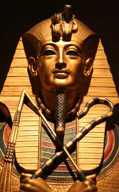
10. คำสาปแช่งขององค์ฟาโรห์
เป็นที่เล่าลือกันว่า ผู้ใดก็ตามที่มาเปิดหลุมฟังพระศพขององค์ฟาโรห์ตุตันคามุน (Pharaoh Tutankhamun) จะต้องคำสาปที่นักบวชไอยคุปต์บรรจงสลักไว้ภายในสุสาน ซึ่งจะส่งผลให้เกิดอาถรรพ์การเสียชีวิตอย่างน่าพิศวงขึ้น เหมือนอย่างเช่นเหตุการณ์ที่เกิดขึ้นกับ "ลอร์ด คาร์นาร์วอน" (Lord Carnarvon) กับคณะสำรวจของ "โฮเวิร์ด คาร์เตอร์" (Howard Carter) ที่เขาได้ว่าจ้างให้ทำการสำรวจค้นหาสุสานฟาโรห์ตุตันคามุน ซึ่งผลสุดท้ายแล้ว ทั้งหมดเสียชีวิตไปโดยที่แพทย์ไม่สามารถวินิจฉัยอาการได้เลย
เป็นที่เล่าลือกันว่า ผู้ใดก็ตามที่มาเปิดหลุมฟังพระศพขององค์ฟาโรห์ตุตันคามุน (Pharaoh Tutankhamun) จะต้องคำสาปที่นักบวชไอยคุปต์บรรจงสลักไว้ภายในสุสาน ซึ่งจะส่งผลให้เกิดอาถรรพ์การเสียชีวิตอย่างน่าพิศวงขึ้น เหมือนอย่างเช่นเหตุการณ์ที่เกิดขึ้นกับ "ลอร์ด คาร์นาร์วอน" (Lord Carnarvon) กับคณะสำรวจของ "โฮเวิร์ด คาร์เตอร์" (Howard Carter) ที่เขาได้ว่าจ้างให้ทำการสำรวจค้นหาสุสานฟาโรห์ตุตันคามุน ซึ่งผลสุดท้ายแล้ว ทั้งหมดเสียชีวิตไปโดยที่แพทย์ไม่สามารถวินิจฉัยอาการได้เลย
วันศุกร์ที่ 30 กันยายน พ.ศ. 2554
Mobile Laser Scanning and Mobile Mapping System
ถ้าได้แบบนี้การเดินทางด้วยเครื่องมือ ที่ทันสมัยจะช่วยให้ความปลอดภัยในชีวิตดีขึ้น
China's space ambition soars

Beijing (CNN) -- China on Thursday launched its first space laboratory module, marking another step upward for its space program. "We must soberly recognize that China's space-station technology is still in its initial stage, compared to those of the U.S. and Russia," said a commentary from the state-run Xinhua News Agency. "But the launch of Tiangong-1 is the beginning of China's efforts to narrow the gap." China-watchers agree. "The test reflects China's technological advances, funded by its rapid economic growth and facilitated by the military's ballistic missile program," says Taylor Fravel, associate professor at the Massachusetts Institute of Technology (MIT). The unmanned space-lab is an 8-ton module named Tiangong-1, or "Heavenly Palace." That's what the Chinese called outer space in ancient times. China launches unmanned space lab Tiangong-1 is designed to stay in space for two years and is expected to dock with an unmanned spacecraft in November. China launches first space docking mission The rendezvous next month will be the true test of the mission, experts say. "Docking is necessary for the development of a space station, which is China's long-term objective," says Fravel. China needs to master this docking technique to be able to build its own manned space station by around 2020. It also hopes to send a man to the moon and even explore Mars, bringing it in the same league as the United States as a superpower in space. For Beijing, this week's launch is more than a space mission. It is meant to boost national pride and prestige. "It is no coincidence that the launch of Tiangong-1 occurs just before October 1," says MIT's Fravel, referring to China's National Day holiday, when the People's Republic was officially established in 1949. "I am very proud of our space program," exudes a visitor at Beijing Planetarium. "Spending on the space program is very necessary to advance science and technology in our country," says another. The test reflects China's technological advances, funded by its rapid economic growth and facilitated by the military's ballistic missile program. Fravel Taylor, analyst China also hopes to reap other benefits. Space missions, experts say, spur technological and scientific breakthroughs in such fields as electronics, computer, engineering, materials and other industries. There are military and electronic-intelligence applications too. And of course, the economic dividends are lucrative. Glitch-less space launches are a publicity bonanza for China's satellite-launch industry, which is already a huge money-making business. China's modern-day space ambitions date back to 1970, when it catapulted the country's first satellite into orbit. I remember how over the years the Chinese proudly spoke of that breakthrough, bragging that the small space module even transmitted the revolutionary tune "East Is Red" as it circled the Earth. But hardly anyone considered China as a serious player in space exploration. Over the years, China has been catching up, pumping enormous sums of money and resources into research and training. "In the early 1990s, President Jiang Zemin gave the go-ahead for a manned space program and the decision set off a tremendous construction boom that was in some ways as impressive as NASA's buildup for the Apollo project in the 1960s," writes James Oberg in his book "China's Great Leap Upward". In 2003, China's first astronaut, Colonel Yang Liwei, orbited the Earth in a Chinese-made Shenzhou capsule before landing to a hero's welcome. Yang's voyage into space -- called "taikong" in Chinese -- gave birth to the new word "taikonaut." Only China, Russia and the United States have sent men into space. In 2004, I joined a group of journalists visiting the Jiuquan Space Center, where taikonaut Yang and the Tiangong-1 blasted off. It was the first time Chinese officials had allowed international journalists into the sprawling top-secret launch center. China's equivalent of Cape Canaveral is an unpretentious cluster of white buildings and towers, tucked in northwestern China's vast Gobi desert. We were forbidden from taking pictures of the command-and-control center but we were shown around the center's facilities, including the launch towers and silos, an Olympic-sized swimming pool and the taikonauts' austere apartments. Might the Chinese become the new space leaders of the 21st century? They just might. China is forging ahead to build its own space station, even though the costs would be enormous, while the U.S. and other space powers have apparently discarded that option. China is not part of the International Space Station (ISS), which currently orbits the Earth while space experts and astronauts conduct experiments in a range of fields, from physics to astronomy. The ISS is a consortium among NASA, Russia's RKA space agency, Japan's Aerospace Exploration Agency, the European Space Agency and the Canadian CSA. The ISS is expected to be phased out in the future. China is now on track to build its own space station. "This is not to say that China will never cooperate with others in space, but it would prefer to do so from a position of strength once it has developed a more capable and robust space program," says MIT's Fravel, who specializes in China's military affairs. Should China's competitors worry about its steady strides? "The U.S. should not be too worried, at least not yet," Fravel says. "Tiangong has been likened to the Gemini program conducted by the U.S. 50 years ago."
สนามโอลิมปิก 2012 ลอนดอนเกมส์ ใกล้เสร็จแล้ว

สมัครสมาชิก:
บทความ (Atom)